

At some time in our history, Ottawa had a direct train connection to the Adirondecks and Tupper Lake in New York State via Cornwall. From there, you could travel further south to New York City. The original dream was to create a direct connection, but that didn’t materialise. How awesome would it be to have a train connection that would still serve this route. Don’t have your hopes up though, as the tracks in Canada have been pulled up a long time ago. On February 14, 1957 the last train travelled on the Ottawa Division of the Ottawa & New York Railway, 67 years ago today.
Fortune seekers galore
The late 1800’s was a very different time. Speed was a very different concept in those days; we can imagine that the arrival of the stream train a few decades earlier must have been a game changer. It turned the idea of transportation upside down. All of a sudden one vehicle, not even powered by humans or animals, could move many people and more cargo over land at a reasonable speed. No wonder all kind of fortune seekers where looking into investing in trains. It was the bitcoin and the AI of the second half of the 19th century. And not only fortune seekers were salivating, several levels of government were also highly interested.
Ottawa Division of the Ottawa & New York Railway
There was interest from railway companies to connect Ottawa with New York, but for many reasons it was never successful. There was pushback from landowners, there were financial difficulties and takeovers. For a while there was a connection to Tupper Lake but in 1932 the train bridge across the St. Lawrence was planked over for use of the automobile and a train connection between Canada and the US was now shared with cars. Thus the car became a serious competitor. After mergers and takeovers, the Cornwall to Ottawa part eventually became known as the Ottawa Division of the Ottawa & New York Railway, owned by the New York Central Railroad. The initiative changed names and merged so many times, it requires its own family tree. For ease of reading and nostalgia, I will use “Ottawa & New York Railway” as its name.

Crossing the St. Lawrence river
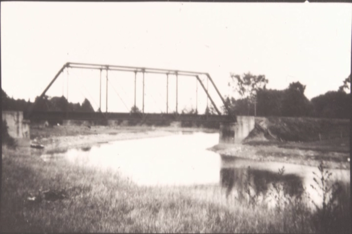
But let’s go back to the late 1890’s. There had been a number of take overs in the USA that eventually resulted in a railroad connection towards Cornwall, while at the same time there had been an initiative on the Canadian side to build a railroad towards the American border at Cornwall. The St. Lawrence was a big barrier though. To solve that problem, a large bridge, or actually two, had to be built as the plan was to cross the river at Cornwall island, part of the Mohawk Nation at Akwesasne. The first bridge built was the bridge crossing the southern channel of the St. Lawrence river, passing south of Cornwall Island. This bridge consisted of 3 Pratt trusses.

Construction of this bridge started in 1897 and was quite unbelievably already finished in the next year; the opening would have to wait until October 1900 though, because another bridge in the network had partially collapsed during construction.
First bridge collapse
As it turned out, building a bridge is one thing, but understanding the geology underneath it is another. Not once, but twice things went wrong, and both times in the north channel on Canadian soil, or rather in Canadian waters.
The first time it went wrong was on September 6, 1898. It turned out that the diver who had inspected the bottom of the channel where the South Ottawa & New York Railway bridge was going to be built had falsely assumed there was rock along the entire width of the north channel. Unfortunately, there was not: there was a layer of gravel on top of 6 meters of clay underneath one of the piers. The weight of the bridge was too much for the unstable layer in the St. Lawrence River and a pier and two spans of the bridge collapsed, killing 15 workers. This collapse was the reason why the train only started in 1900.

Second bridge collapse
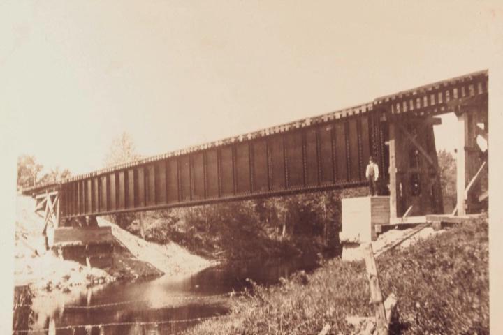
A second accident happened ten years later at the swing bridge across the northern channel on June 23, 1908. The bridge, that looked similar to the Alexandra bridge in Ottawa, had an extension at the north side that crossed the Cornwall Canal. In the centre of this extension was a big horizontal wheel, that would swing the bridge 90 degrees horizontally, so that ships could sail through the canal. After the ships had passed, the bridge would swing back in place again. It was this part of the bridge that collapsed into the water due to a breach in one of the canal banks the pier was standing on.

The Ottawa & New York Railway Roosevelt International Bridges
The bridge crossing the south channel was owned by the Cornwall Bridge Company and the north channel crossing was owned by the Ottawa & New York Railway. Eventually, the name for both bridges became the ‘Roosevelt International Bridges’, but only in 1934. I had a bit of a hard time figuring out which bridge was which initially as people refer to ‘the bridge’ or the ‘American side’ which turned out to be the south end of the bridge across the north channel, which is all Canadian still.

USCAN station
The first option to get off the train in Canada arriving from the USA was a station called USCAN on Cornwall Island, named after, you guessed it already, US-Canada. Your last station in the USA would have been Nyando, as in “NY and O”, later changed to Rooseveltown (indeed, with one t). Had you stayed on the train, your next stop would have been Cornwall Station on mainland Canada. After the railway shut down, the USCAN station became someone’s garden shed.
Travelling north on the Ottawa & New York Railway
Travelling further north, the train would cross the east west Grand Trunk tracks and then pass several places such as Black River, Harrisons Corners and Northfield. The train didn’t go very fast, around 65 kph per hour, and there was even the joke that you could jump off the train, pick flowers while running along and hop on it again. The trip from Cornwall to Ottawa would initially take 2 hours and 20 minutes to cover 60 km, an average of 25 km per hour, but that includes the stops.
The train then crossed the Canadian Pacific railway track just north of Finch and had to cross the Nation River at Crysler. If you ever visit Crysler, you can still see the concrete remnants (called abutments) of the bridge.

Embrun and Russell
As the train was travelling further north towards Ottawa, the train had to cross two more creeks south of Embrun, just north of 1516 St. Joseph Rd. and west of 1452 St. Joseph Rd. Further north, the train had to cross the Castor river (French for Beaver) in Embrun – St. Onge, and then continue to Russell. The original New York Central Railway bridge here was built in 1897 and looked similar to the bridge that still crosses the Rideau River near the Ottawa GGs stadium.

Flag stations on the Ottawa & New York Railway

Leaving Russell, the train had a straight stretch ahead, towards what are now already the outskirts of Ottawa, but at that time were somewhat isolated rural places still. You would pass stations such as Pana, Piperville, Edwards and Hawthorne. Some were flag stations, others had an actual building as a station. You are hard pressed to find any evidence now of where the train came into Ottawa, but there are still hints, such as narrow corridors in industrial areas and the unused bridge across Innes.

Hurdman Station
Eventually you would cross the Rideau River into Ottawa proper, just after you had passed Hurdman station, which was further north than where it is now. Hurdman station was just a small storey place (I am estimating 5 x 10 m) where several tracks intersected. The train would cross the Rideau River using the steel CAR train bridge that is still there and which is now used by pedestrians and cyclists. It is the one south of the Queensway and east of the Ottawa GG’s football field. From old aerial images I deducted the station used to be here (red square):

J.R.Booth
While the (now American) owners had assumed they could use the existing tracks into Ottawa, J.R. Booth, owner of the Canada Atlantic Railroad (CAR), had no desire to accomodate the Ottawa – New York adventure and basically not only said no, he also built a warehouse exactly where the O & NY Ry tracks would have gone in. Only when the government stepped in, the Ottawa & New York Railway could actually arrive at Grand Trunk Central Station across from Chateau Laurier: both opened in 1912. The station was renamed to Union Station in 1920. The trains from Tupper Lake and Cornwall would likely have arrived at one of the many platforms south of Union Station though, not next to the canal near the Chateau.

Arriving in Ottawa: Union Station
After the CAR bridge, the tracks would roughly follow the route where the Queensway is now and hit the canal at the sharp bent. It would than travel north along the Rideau Canal eastside towards Union Station. This route is now Colonel By Drive and its adjacent multi use pathways.
The last ride
Unfortunately, the venture wasn’t a very profitable enterprise (if at all) and sadly in 1957 it folded. The dream of a direct connection between Ottawa and New York never materialised, but one could change trains in Tupper Lake and make it to New York eventually. In 1954, on April 24, the last passenger train rumbled through the towns and villages in Eastern Ontario. Three years later, the New York Central Railway ran its very last train on February 14, 1957. CN Rail had already bought the line and quickly ripped up the tracks for use in Montreal. Later that year, on December 20, the Ottawa & New York Railway was dissolved. An era had come to a close.
Cycling parts of the route of the Ottawa & New York Railway
If you are 70 -75 years or older and from that area, you probably still remember that train though. And if you don’t, there are several places where you can cycle to take in those historic days. You’ll need a lot of imagination though. But let’s make an attempt.

Downtown Ottawa
Starting at Union Station in Ottawa (now the temporary Senate building) you can cycle down the canal along Colonel By Drive until the canal turns sharply right. In this corner, the train would veer left, away from the canal. You can pick up the route again roughly at Lees Ave and cycle around the UOttawa Lees campus to see the Rideau River Footbridge, a former Canadian Atlantic Rail bridge. Going straight after the bridge on the gravel path you’d pass what used to be Hurdman station, but there is nothing left.
Then the track would cross Riverside and right through where the station building of VIARail is now. You could somewhat emulate that up to the building via the bike paths. If you are at the VIARail station, briefly check out the train models inside the station. You would then have to find your way to the Train Yards Mall which is an absolute pain to get at from the train station. The tracks would run on a stretch behind Marshalls, Sail and Movati. If you have a coffee and a bagel at Kettlemans, know that this is exactly where the train would run.
Science and Tech museum property
You can then check out the bridge across Innis Rd, which is still there and then continue to the back of the Science and Tech museum property. The route used to run right there. Then it’s getting really hard.

Russell and Embrun
But -redemption!- Russell and Embrun turned the Ottawa & New York Railway stretch into a multi use recreational pathway: “the New York Central Fitness Trail“, a 7 km paved stretch. You can pick up the trail for a bit in Crysler, but only as part of a 3 km walking trail, known as the “Bell Canada Trail”. Why Bell? Because Bell is using it to run fibre through the corridor.
The Waterfront Trail Cornwall canal dam
After that, it pretty much becomes impossible to bike, save perhaps for some short stretches for gravel riding here and there (note: happy to hear more if that is possible). One last chance is the pathway on the dam along the canal in Cornwall, where the swing bridge collapsed. You can take the Waterfront Trail from the powerdam, and bike along the canal towards Cornwall. You can still see several piers and if you look carefully, the collapsed wheel of the swing bridge that lies just below waterlevel, still visible.

The future of the Ottawa & New York Railway
Sometimes I wonder what would have happened if the tracks had been maintained and improved for fast commuter rail. Would villages and new exurbs with their own bustling cores have grown along fast transit? We’ll likely never know. Alternatively I can see tourism being developed more or less along the corridor if enough stretches are rebuilt for active transportation, similar to the Great Allegheny Passage in the USA or the P’tit train du Nord or the Estriade in Quebec.
Video of the route
I spent the Christmas holidays partly figuring out how to somehow animate the former route of the Ottawa & New York Railway from Cornwall to Ottawa. I started out with an animated line across the landscape, but from one thing came another and I ended up going terribly overboard without having any actual animation skills.
But since there was neither snow nor ice to ski and skate on in Ottawa over the holidays, I think it was time well spent, if only for the learning curve.
The clip starts at Cornwall and ends in Ottawa. It has no voice over. Along the way, the station names pop up. I ‘borrowed’ some steam train sounds from the internet to give it a bit more period ‘je ne sais quoi‘. I would love to create a little steam train huffing and puffing through the landscape, a la ‘Polar Express’. But until then a red line must do.
Sources for the Ottawa & New York Railway
The website containing most information is the website by Chris Granger from Cornwall who has been dedicating a lot of time trying to dig up the nearly lost and scattered information about this railway. Chris cleared up a few bits and pieces for me that I wasn’t really sure about: https://www.nyc-ottawadivision.com/
Photos Embrun: https://www.tfcg.ca/history-of-embrun
Old maps: http://digitalarchive.mcmaster.ca/islandora/object/macrepo%3A88086 (awesome source)
Inspiration and train in Ottawa photo: https://churcher.crcml.org/Articles/Article2003_5.html
More bridge photos: http://www.cornwallpostcards.ca/
Ashely Newall: https://apt613.ca/capital-history-ottawas-union-station
Locomotive cartoon in Cornwall Island map: Ovidio Timplaru
Geo Ottawa maps (the aerial images section)
Google screenshots
Reading up on railways is a rabbit hole that is hard to get out of. I even ended up checking old railway fonts. Wouldn’t you know there is a website and people dedicated to railfonts and decals for model trains: http://www.railfonts.com/ by Benjamin Coifman
More railway related blog posts:
- The Short Life of the Ottawa & New York RailwayReading Time: 12 minutesAt some time in our history, Ottawa had a direct train connection to the Adirondecks and Tupper Lake in New York State via Cornwall. From there, you could travel further south to New York City. The original idea was to create a direct connection to NY, NY, but that didn’t materialise. (with video of the route)
- A 52 km loop along the Estriade and Yamaska National Park in Quebec
 Reading Time: 7 minutesThe Estriade is a 22 km bicycle route on a former railway bed. Combined with a route through a National Park, it makes for a lovely 52 km route, all on separate pathways.
 - Retracing the First Train into Ottawa: the Bytown & Prescott Railway
 Reading Time: 10 minutesMr. Walter Shanly (1817-1899), a civil engineer, touched the ground to inspect the land underneath his snow shoes. He was on a mission: recently he, and a group of investors, had agreed on building the first railway track into Bytown (now Ottawa), all the way from Prescott on the St. Lawrence river, to connect the lumbertown on the Ottawa River with the ports in Prescott. A distance of about 50 miles (80 km). Not everyone was excited about their plans though and it had taken time to get the funds together. Thomas McKay, who built Rideau Hall, put forward money [Read more…]
 - Prince of Wales Bridge Reopens as Active Transportation Bridge with New Name
 Reading Time: 8 minutesA large piece of new active transportation infrastructure finally opened yesterday. Here is all the background you want to read about the historic Prince of Wales bridge, now the Chief William Commanda bridge, connecting Ottawa with Gatineau and an easier gateway to Gatineau Park.
 - Cycling the Ecopista de Évora in Portugal
 Reading Time: 8 minutesThroughout Portugal you can find an increasing number of dedicated cycling facilities, often called Ecopistas. This week, we’ll take you on an interesting ride on the Ecopista de Évora in the Portugese province of Alentejo, known for its cork trees, white washed villages, wine and vistas.
 - A bike ride on the Ecopista do Dão in Portugal
 Reading Time: 7 minutesThe Ecopista do Dão wasn’t on the agenda for our trip in Portugal, but we found this gem of a rail to trail in the hinterland of Portugal. Closed for trains in 1988, it is now a paved trail through a lovely, peaceful part of rural Portugal.
 - The K&P Trail in Kingston, Ontario
 Reading Time: 8 minutesSummary During a stay in Kingston, I explored the city’s waterfront and the K&P Trail. A lovely 30 km route that touches on many different aspects of Kingston. It needs a few improvements, such as crossing the VIA Rail tracks on Division Rd and access to the trail right after the overpass and the Sydenham Rd crossing. Wayfinding could be improved: despite some prep at home, I still managed to miss part of the trail. You can do it in two hours or take a whole day if you stop for museums, craft beer and lunch in the park. I [Read more…]
 - The incredible service of the Dutch railways returning my backpack within three hours
 Reading Time: 4 minutesLast Saturday I took the train of the Dutch Railways (NS) from a small town north of Leiden to Aardenhout south of Haarlem. When leaving the train, I forgot my backpack.
 - Back from Holland – The Train System
 Reading Time: 8 minutesThose who follow me on Twitter (@HansontheBike) got a pretty good impression of what I have been doing the last three weeks. Karen and I were in the Netherlands. I live in Canada and although on average I go back once a year, it is often for work, which means I can only add a day or two to my trip in the weekend. We also go to other places in Europe, but we make sure we make a stop over in the Netherlands for 4 to 5 days. However, in all those 17 years I never went back for a [Read more…]
Related


Discover more from Hans on the Bike - Cycling in Ottawa and beyond
Subscribe to get the latest posts sent to your email.

This is amazing Hans!! Great info and well presented! Excellent animation too!!
Thank you Greg, a lot of time went into it as the story is quite confusing when you start reading about it in bits and pieces. Fortunately several people started documenting it so this nearly forgotten railway gets some more attention again.
Thank you Greg. It was work but it expanded my skillset and knowledge