
Last Saturday, the renovated Main Street in Ottawa was officially opened. The opening of this brand new complete street was folded into the annual Main Street fest and part of the street was closed off for motorized traffic. There was a brass band playing, there was an artisan farmers market, there was the bouncy castle (no event in Ottawa is complete without a bouncy castle, face painting and a booth of Safer Roads Ottawa) and there were hamburgers (veggie and halal included) for the fundraising part of the event.
Cast iron for David Chernushenko
From the tongue-in-cheek gift of the community association to city councilor Chernushenko, a tiny piece of cast iron sewer pipe to hang around his neck, I understood that the reconstruction of Main Street was triggered by a necessary replacement of a sewer main, often a reason to remodel a whole street rather than remodeling for the sake of remodeling for safety only.
Main street arterial
The Old Ottawa East Community Association was very much involved in the development. Main street, as it name implies, feeds lots of traffic into the city centre. It had grown into a four lane arterial road of which there are tens of thousands in North America, where car is king, despite having retail, a university and houses along the street. Pedestrians were assigned to narrow sidewalks and the residents who choose to bike, well….”go somewhere else”.
Large development along Main St
Coinciding with the remodeling of the street was the start of a development of a large piece of property sold by a Catholic religious order. The eventual development of that property will make Main Street a much more central location as it is now, making it even more necessary to develop it into a complete street. Read more about the background of the Oblate lands here: Background of Oblate lands.
When car traffic is affected, people tend to be up in arms. While the community argued that it is their main street, their safety and therefore their right to have the most important say, a councillor further south organized her own open house in her own ward, concerned about the extra 1 minute that city staff had calculated it would cost to travel down Main Street. This however, is partly politics I suspect so that the concerned car commuters could not blame the councillor for not standing up for them. In all fairness, resistance wasn’t as high as was expected. Let’s not forget though that councillors Moffatt, Blais, Hubley, Desroches, Deans, Harder voted against Main Street’s changes.
I am sharing a number of before and after photos below plus some examples that I think could be further improved. Unfortunately some photos went missing when transferring it to my desktop, but I will add another blog post later this month.

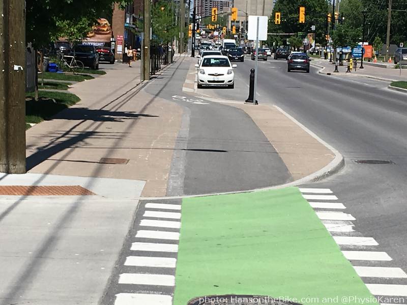
In the photo above, you can see the bike track is passing a bus stop. This was experimented on Churchill Ave already. With on road bike lanes, the bus has to stop in the bike lane, but in the bike track configuration, another solution had to be found. The saw teeth are a warning for both peds and cyclists that they have to look out for each other. This set up looks easy, but it took a lot of discussion if this was safe. The concern was partly fed because cycling in North America has an aura of speed. Here, there will be people lingering in the bike lanes waiting for a bus; as a cyclist you have to anticipate this and carefully go around people. Not everyone is used to bike tracks yet.


In the photos above, you can clearly see a before and after situation. The outer lanes, which were often used for parking have been reallocated mostly to cycling, walking and parking bays. Hydro poles are a bone of contention: everyone wants to get rid of them, but no one wants to pay for it. (For my non-Canadian readers: hydro poles have nothing to do with water, but with electricity, even though most power in Ontario comes from nuclear plants).


The pavement is a combination of asphalt, concrete and pavers. Pavers generally don’t hold up well for motorised traffic: they start to chip and fall apart. I don’t know if it is the quality of the materials, the winter tires or the freeze-thaw cycles or all of the above.

Ideally, the city would have raised the track in the intersections, especially here at the entrance to this community in the photo above. It would have given it more of a message: “Hey, you are entering a community here, slow down”.

The view point in the photo below is the dead end circle in the bottom of the previous photo.

Improvements

There are a few improvements needed though. In the photo above, the bike track stops at the stop sign at the light. It doesn’t continue as a path though. I am not sure if that was intentional. The reality will be that cyclists and pedestrians alike will stop at the curb in a ‘shared space’ like environment. The part that I added in gray would have made the cross walk crossing the space a bit more obvious I think.
But what really needs to be modified is the curb cut at the arrows. It is basically forgotten and too high.
Also in the picture above: the green line is the desire line coming from Main into Riverdale east bound. Main slopes down a bit and no cyclist will hit the brakes, come to a full stop, look left and right and then turn a sharp right when you can bypass the lights instead and maintain your speed somewhat. So be prepared to see that happening by default.

Another place where lights will be totally ignored is the top end of the T-intersection in the image above. If you follow the green arrow as a pedestrian you have no signal. It makes sense as there is no one to wait for. I can tell you right now, that -unless someone with a stroller is crossing your path- no cyclist is going to wait there either. I bet you that most cyclists will not even notice the light (see red arrow). A better solution would have been a bypass similar to pedestrians. Having to stop when you generate your own power is already a pain and if you want to make for example commuting by bike more attractive, one of the top implementations is to allow cyclists to flow as much as possible. Wasn’t that the mantra for traffic in the first place?

Above: Coming from the canal on Hawthorne east bound (I know, the red line should be in the other lane, where the blue vehicle is), crossing Main to turn left, I found myself lost in the area of the green circle. There is no place to line up. This is a pre-redesign image obviously. I don’t have a drone and father’s day didn’t provide me one again this year. It is probably not a move many cyclists make though. The corner where the red arrow ends is well designed. I took a pic there, but it mysteriously disappeared from my camera, together with the clips I made of the murals.

If you are still with me, you have to realise the Main Street reconstruction is a huge deal for Ottawa. Huge with a capital H. It took political courage, a huge effort by the community, supportive city staff and lots of design discussions. If this is successful (not only for cycling, but for everyone) and I believe it will be, then future projects will be so much easier.
A sewer project is not a bike project
As is so often the case, a sewer project is not a bicycle project, meaning that the projects don’t always sync with the cycling utopia. Main street for example connects to a bridge at the south end which only has bike lanes. When I asked a number of years ago if the bridge could get raised bike tracks while they were renovating the bridge, it wasn’t possible. I didn’t completely understand why, but it had to do with drivers being able to veer out of their the lane if needed. A curb would be too dangerous for drivers (!). After the bridge there is an unpleasant intersection to cross if you want to connect to Smyth Road and into the entire Alta Vista area, even when you decide to use the hospital property to connect to cross the railway tracks.
At the north end, much to BikeOttawa’s chagrin, the complete street turns into a not so complete street towards the canal. At that time there was ‘not enough space’. Recently though,I saw drawings to make that stretch to the canal complete too, with improvements on Colonel By for better connections to Main Street. So while not complete entirely, more changes should come.
For a flash back to the first remodeled but somewhat lesser important Churchill Ave, see this blog post from 2014. Watch the opening of Main street here:
Hi Hans, i really liked your blog. A question. You note at the end “If you are still with me, you have to realise the Main Street reconstruction is a huge deal for Ottawa. Huge with a capital H. It took political courage, a huge effort by the community, supportive city staff and lots of design discussions. If this is successful (not only for cycling, but for everyone) and I believe it will be, then future projects will be so much easier.”
Now that 2 years have passed, what is your assessment? Has it been successful and well used? Had it spurred more complete streets?
I think the bike system on Main St is phenomenal. As someone who lives directly on main I think this is a step in the right direction.
The only thing I wish would be communicated better to both cyclists and pedestrians would be the saw tooth lines in front of the bus stop. People often wait for the bus there and it can get a little hairy.
this is a prime example of how Ottawa makes roads more dangerous for cyclists while implementing a very costly solution. Bikes are traffic – we are – it is simple. look at hunt club, look at Terry Fox, look at baseline from roberston to greenbank [when it isn’t used as a snow dump for lazy plows]. that is all we need – main st is just confusing, slow, unplowed and expensive – a D- in my opinion
It depends a bit which angle you take. Cycling is in Ottawa is slowly picking up and I’d like to think that is because we build a safer and better connect road network, like some of the European countries do with spectacular results. The solutions are not very costly though, they actually dirt cheap, especially when the road is dug up for sewer replacements anyway. If you want to have a future generation out on the bikes, you need safe, connected routes. I much more enjoy cycling on separated tracks without having to worry about careless drivers texting. On the other hand, if you are a confident cyclist and want to put the kilometers in, and you have no fear for 18-wheelers and erratic drivers, I can see that you rather cycle on the road. The reality though is, that the vast majority of people sits on the fence and will only bike when the network will be safer. I actually think Main street is fairly well done. It is not 100% and I find for example the hydro poles too close to the bike lanes, but I think it definitely improved the streetscape.
1. That’s what those zigzags are? This has not been well communicated to the non-biking public.
2. Those spots where the bus shelter is set back waaaaaaaaaaaaaay far from the curb to accomodate the bike track = lots of skipped transit passengers who are sheltering from the weather, who the bus driver will feel entitled to pass on by because they aren’t waiting at the flag.
Also:
“Some of the fire hydrants, hydro poles and trees are very close to the bike tracks. I think they are too close. It feels like you are going to hit them with your shin or your bars.”
Is that not the same principle that is lauded when it causes car drivers to maintain a reasonable speed?
Perhaps not. The hydrants could cause harm, which I doubt would happen to me if I’d drive and scrape a hydrant. Plus if drivers are nudged to slow down, trees would usually be a reasonable distance form the road, not half a foot. They be planted, just like narrower lanes, for the visual effect, less to damage a vehicle or driver.
Ottawa’s network of high speed streets and roads wasn’t built in a day. It was built segment by segment over decades. Similarly, better walking and cycling facilities will be built in segments, and connected up over time, as users appreciate them and demand more. Acceptable designs will also evolve over time.
Personally, I think our cycling infrastructure has gone from begrudged to minimal to a genuine concern that it should work better. With further encouragement, it will soon become very useful.
From the initial recreation paths to the “bike west” proposal to complete streets, cycling facilities are proliferating. I note with surprise I can now cycle from my home via cycle tracks all the way to the library and then back home via the glebe or canal or trillium pathways and never be on a busy road. That’s progress.
To Eric: Ideally, the more space between a bike track and motorized traffic, the better. I would say that everywhere where motorized traffic is allowed to go over 50 km (30 miles) per hour, you’d want separation. However, there are sometimes exceptions if you are retrofitting streets in tighter urban spaces. I guess if you have to choose between no separation because there is no ideal solution possible, or a less ideal design, then you have to make concessions. With a narrowed Main Street and a maximum speed of 50 kph you can probably get away with some areas where traffic is closer than you’d ideally like. Merivale Road may have some issues too, but Albert through the Flats should have lots of space to create proper separation. there comes a time that (gasp) we may have to reclaim a lane from motorized traffic such as at McKenzie and O’Connor.