

This spring, when visiting my family in the Netherlands, I passed through a small place called Zwaanshoek. The village, originally part of another municipality, sits on the edge of a former lake.

The whole area where we were driving, known as Haarlemmermeer (Haarlem Lake), used to be a lake, but when steam machines pumped the entire lake empty in the 19th century, it became fertile agricultural land. Storms on the lake had been driving the water dangerously close to the edge of Amsterdam and Leiden, so the Dutch eventually decided to just get rid of the lake altogether.
Fun fact: Schiphol airport was built at the bottom of a lake. The name ‘Schiphol’, was derived from ‘Scheep’s Hel’. (Schip’s Hell)
Cruquius steam powered pumping station

One of those steam powered pumping stations can be admired in Cruquius, now a National Heritage Monument. It’s quite a contraption, lifting the equivalent of the volume of a (Dutch) house out of Haarlem Lake (according to our guide) every time they pull up their buckets of water. It’s piston is 144 inches (3.7 m). It is worth a visit; it is an easy cycling distance from Haarlem train station.

Bennebroekerweg T-intersections
When driving through the Haarlemmermeerpolder (the area kept its name) with my sister, I noticed the town modified the intersections on the Bennebroekerweg (Bennebroek Road) through Zwaanshoek. It’s an interesting design that I had never seen before. They basically chopped the road in smaller pieces to slow down traffic on this road aligned with houses.
Before the changes
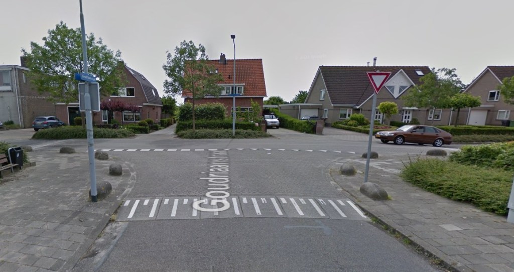
It used to be a road where road users from side roads had to yield to traffic from both directions on the main road. There was no incentive to drive slower on the main Bennebroekerweg thoroughfare, other than for the somewhat raised intersections. We know these situations all to well in Ottawa.
After the changes

If you take a closer look at the ‘after’ picture, you will note that the T-intersections look slightly different now. The main road now appears to veer into the side roads. That is an interesting modification, as the majority of the drivers will want to follow the main road desire line. Which means they now have to turn right! Or left if you come from the other direction.


Interestingly, you will notice that there are no large signs telling you what to do, no stop signs, no yield signs, no traffic lights, just a fairly subtle redesign every hundred meters where a side road meets the main road.
This looks like a minor modification for a T-intersection that doesn’t break the bank. Yet it completely changes the road.
But how do people know who will stop at that T-intersection?
In the Netherlands, traffic coming from the right has right of way (bicycles too!) unless a traffic sign tells you otherwise. That saves an aweful lot of traffic signs and -Dutch traffic psychology- it keeps drivers more alert to figure out what they can expect.
It is one of those rules that keeps traffic slower. It is also a pain in the neck when you take your drivers test. If there is a car or bike coming from the right and you hit the brake just a bit too late, you failed your drivers test. The examinator has their own brake system in the car you’ll do your test in and if they hit it before you, well, that is about the end of your test. Traffic coming from the right and the Hofplein mega roundabout in downtown Rotterdam were concerning for aspiring drivers like myself.

So does the new T-intersection work?
I did drive through this T-intersection too, and I definitely slowed down when ‘turning right to continue straight’. And that is exactly the purpose of this smart and affordable road redesign.
Read about a bike tour in Haarlem here.
Alle traffic streetview and aerial images from Google. Maps from the Internet.
Leave a Reply