

Have you ever wondered how our regional bike network would look like if it were a subway system? I thought it would be a fun project to figure that out for our cycling network. During our 2020 Stay At Home Christmas (not that it had much effect in the end as 50% of the Canadians visited family anyway) I sat down and designed this first draft of the subway style map of Ottawa.

Early summer last year, I published a map with all the existing multi use pathways (MUPs) in Ottawa. First on Twitter for some feedback and oversights, then on my blog. It was well received and I got several great reactions and suggestions for further improvements. As it turns out, not everyone knows that we have so many MUPs in the region. This is something I had been suspecting for a while already and it was one of the reasons why I am putting the maps together.
Cycling related searches
I received many hits on the map section of my blog this summer. Not surprisingly as everyone was looking for things to do. Google confirmed last December (2020) that Ottawa had the highest growth in Canada after Vancouver in the search engine’s hits for cycling.
Node based network base for subway map
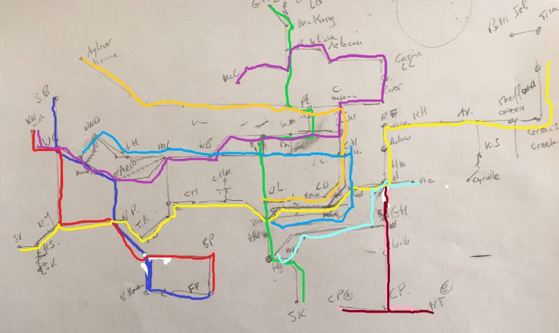
To create a subway style map of an existing network, one needs to create the ‘stations’ first. We don’t have a numbered node based network, instead we give pathways names or a route number.
I strongly believe in a numbered node based network, something that is common in Belgium and the Netherlands and is now spilling over into other European countries. Canada is not at the forefront in way-finding for cycling and walking, which is not only important for tourism, but also for locals to get a better grasp of our network. You can see more on how node (or junction) based cycling networks work here and in a video by Mark Wagenbuur.
Phase 1 Ottawa

I had to invent many station names. This was a bit of a creative exercise. It is not like we are living in Paris or London where every station is at some square or historic building or park. Some of my ‘stations’, especially in Gatineau, are at intersections with Walmarts and A & W Burger joints. This was a bit of a challenge sometimes because I wanted to try to avoid commercial names. I aimed for landmarks, parks, or geographical locations if possible. Several of my loyal readers helped out with naming some nodes.
2020 Lockdown Christmas ideal for subway map
Before you ask me why certain MUPs are not on the map, here is a bit of background. You have to bear in mind that a bike is not a train. A train is tight to rails whereas a cyclist can take a quick shortcut or chose any route one likes. You can not just draw a layer of railway tracks over an existing bicycle route network. This caused some issues as I could not simply convert our entire MUP system into a subway system.

Therefore you will miss certain MUPs that I could not integrate. There would be too many short stump routes between two ‘stations’. I have tried to incorporate as many bicycle network nodes into the subway map though without creating two dozen routes, which would make the map way too busy. This is why you see some odd routes, that wouldn’t make much sense if you’d bike it.
Combination of routes
You will also notice that I cheated a bit here and there by using some on road cycling routes to connect a few lonely stations. If I was a purist, some ’subway tracks’ would miss a few kilometres here and there. An example is the short route from St Laurent to Ken Steele Park. The map as you see it now is a combination of 95% MUPs, a bit of on road cycling and popular routes.
Before I started this, I did a lot of reading on transit maps. It has been a bit of a rabbit hole with a high nerd level. I got a lot of inspiration from Chris Smere (@transitdiagrams on Twitter). Typical for stations on transit maps for example is that they don’t match up geographically. Stations are closer or farther in reality. It is common to space the stations apart at equal distance on maps.
A useful map?
Is a metro map for cycling useful? I think it has a function in visualizing a network in an easy and pleasing way.
In the end it is more a fun project than a bike map avant la lettre. It’s a conceptual idea of our network presented in a different way. More on my map adventures at my special map page.
Hans on the Bike: I heard your CBC morning interview 14 April. Your regional bike map is brilliant. Thanks for your enthusiasm, initiative and dedication. Ride on! Lori
Hi Lori
Thanks for that. There has been an overwhelming response way over a thousand visits on my site today. I am blown away.
We would like to get some laminated copies to hang in our Sandy Hill /Centre town apartment buildings. Do we have your permission to have some printed?
Sure, that would be great. Use the PDF file as it has a higher resolution.
Many thanks and thank you for creating it!
Thanks very much for creating this.
You are more than welcome.
Very entertaining trying to visualize the actual paths on the ground. As of course you know, orientation and distance are not critical for most subway travellers, but are vital for cyclists…
Looking at the south shore Ottawa River path reminded me that for six months of the year there is a big hole in this route at the canal locks. All the gates remain open when the water level is lowered. Surely even the NCC could come up with a cheap gangway that could be thrown across for this period.
Last time I was there, only the upper locks were closed so that you could cross but that makes it a real hassle on the east side of the locks.
Fun project and a nice styling improvement really gives it that underground/subway/metro look. Very artistic!
Is it available for download?
The last sentence in the blog has a link to a PDF with a printable map of 8.5 x 11, if that’s what you are looking for.
Great concept for the bike/subway map!
I thought it was a good concept to visualize a bike network.
Don’t know why it’s taken me this long to look closely at your maps. What a great idea for a Metro map. I look forward to using it come spring.
I update them regularly based on new information.